In the field with the last FAIMS 2.6 module
In this blog post, we handover to Macquarie University researcher Tess Nelson to reflect on the last FAIMS 2.6 module we will ever1 design. Working with supervisor Professor Grant Hose, Tess and their team have taken this module out multiple times over the last year to do groundwater sampling and vegetation observations.
Sunsetting FAIMS 2.6 — the last in-field observations
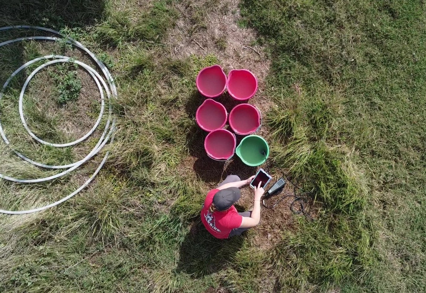
Using FAIMS 2.6 has been an amazing experience. The team at FAIMS have been so gracious with their time helping me and my team from the Freshwater Ecology and Ecotoxicology Lab at Macquarie University to develop a module specific to our field needs. The team at FAIMS have been incredibly patient throughout the process of module development, testing, editing the module, testing and editing again and again until we got the module just right!! I’ll admit I was a little fussy developing our final module but for me it was well worth the extra work. I am incredibly grateful as the module worked seamlessly on our recent two-week field trip sampling aquifers throughout the Macquarie, Gwydir and Namoi river catchments. I’ve just done the data download and its all there (yippee!!) photos included and all backed up (probably the most important part!). The process is so simple and user friendly, I honestly can’t believe I use to do all that data entry converting our old paper field sheets into excel at the end of every trip and now all I have to do is hit download! I honestly couldn’t recommend FAIMS and their team highly enough, if you’ve been considering switching to an electronic data entry system the time saved by not having to do all the post trip data entry really just sells itself!
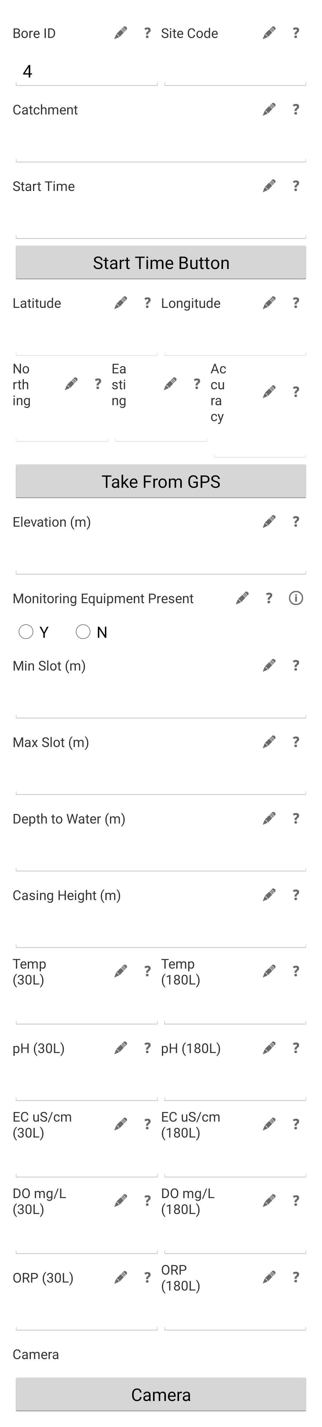
Some of my favourite functions on our module are the GPS and time grab buttons: as long as your device has location abilities all you have to do is hit the button and BAM all GPS coordinates, eastings and northings are automatically imported. This function is great for me as I can easily import these into GIS software and create maps of our site locations. The time grab, which works in the same fashion as the GPS button, is also really helpful and I think it was created just for our module. We needed this function because at the site we have water level loggers that have to be removed prior to sampling, having the accurate time stamp of when this occurs allows us to calibrate this time to the change in pressure that the logger records and water level accurately. Lastly, on our latest module we have added this fantastic vegetation tab which allows us to add entries for each tree of interest in the local vicinity of our groundwater bore. This list of trees and all the info associated e.g. height, species and health conditions etc, is located within the site’s field entry. Therefore, it’s all linked and we can know how many and which trees samples were taken from at each groundwater site, and even more importantly it has photo capture abilities so the pictures saved can help identify each specific tree species if we were unsure in the field.
For me our module works incredibly well for our specific field needs, I even have a checklist inbuilt that reminds me if I have collected all the water quality samples that I need (there’s about 6 little bottles I need to fill and I normally forget one…or two). The capabilities of FAIMS seems endless and like previously mentioned so user friendly even my supervisor (who only upgraded his old Nokia to a smart phone about a year ago) can use it! If you decide to give FAIMS a crack I hope your experience is as seamless as mine has been, and my journey with FAIMS has really only just begun….
Rebuilding this module as a FAIMS3 Notebook
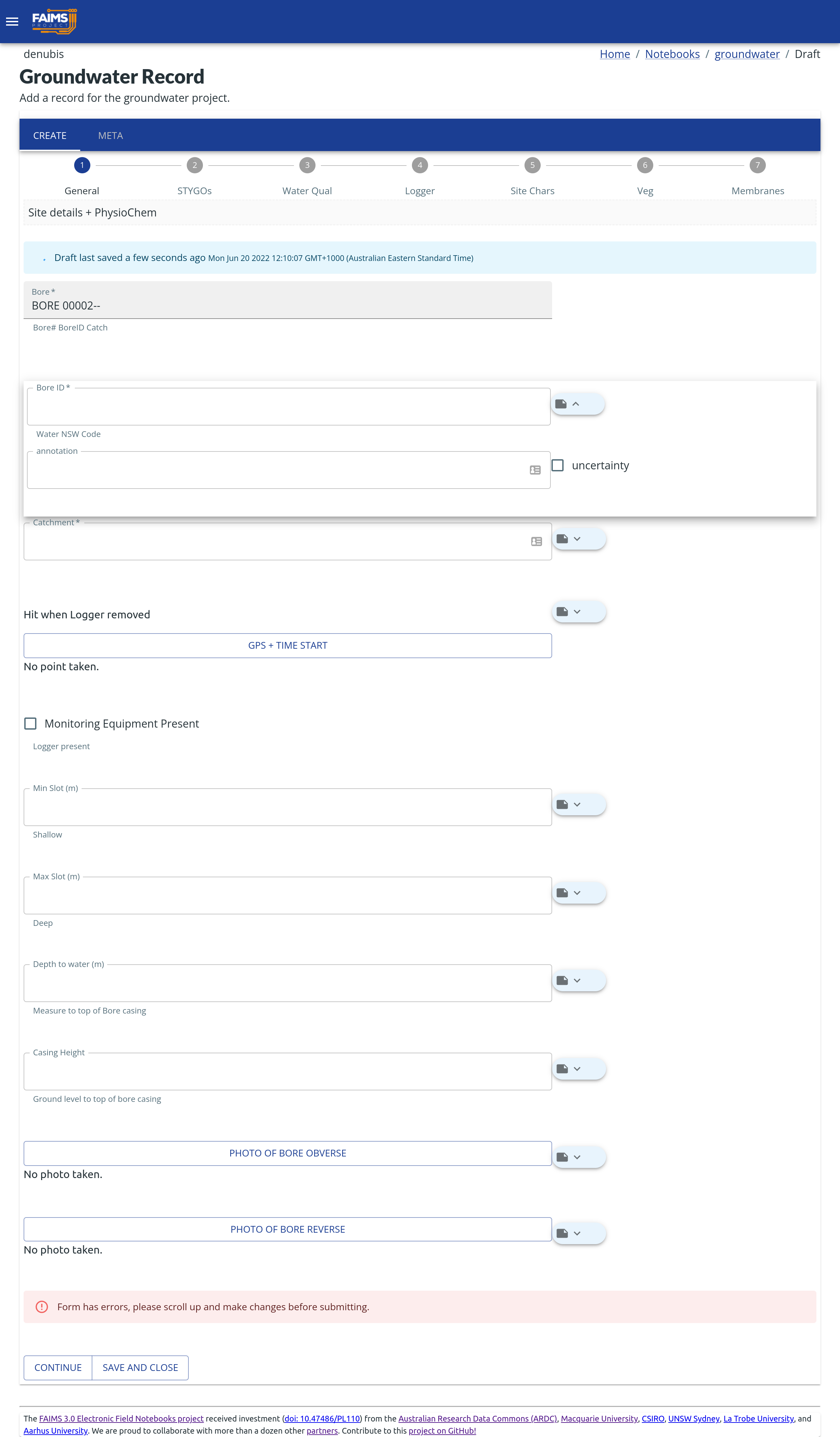
It’s now been a few months since I wrote the first half of this blog, and during that time Brian and I have been working together to move our module onto the new FAIMS3 platform. Firstly, WOW what a change, I love the flexibility that FAIMS3 provides. Firstly, it has retained all functionality and ease of data input that FAIMS 2.6 offered. The biggest improvement is that FAIMS3 now allows users to design and edit modules notebooks with ease. It is so functional and easy to develop a module specific to your needs: it’s as simple as selecting the type of function you want e.g. new input box, adding a label and if for example it is some form of measurement changing the configuration to numeric. Also, there is an automatic “helper text” box which allows you to add additional info or instruction to assist the user about the information required. Then you just keep building from there until the module is complete. Again, similar to FAIMS 2.6 I have a number of tabs to organise my data input into sections that flow for my style of field work.
I love that now my module can continually be updated and improved, each time I have trialled it I have found little tweaks that can make it better and its just so easy to go and fix them up myself. I expect once given a full trial run in the field that again I’ll have updates and the module will just keep getting better and better with use.
Again, I just want to thank the FAIMS team for helping me develop the module and now bring it up onto the FAIMS 3 platform. It’s been a joy working with you and I look forward to developing more modules in the future.
Brian here: I so very much hope that this is a true statement…
For more news, subscribe!